Find Your Daily Voice
 54°
54°
Snow Squalls Smack NJ, Temps To Plummet (Video)
The first day of spring is behind us, but winter seems to be sticking around.
Snow and rain showers were possible Wednesday evening, March 20, with some snow squalls already having smacked the northernmost parts of New Jersey.
From a spotter in High Point earlier, around 4 PM, where 1 to 2" of snow fell quickly in northwest Sussex County NJ, as... Posted by US National Weather Service Philadelphia/Mount Holly on Wednesday, March 20, 2024
According to the National Weather Service, flurries were possible in Warren, Sussex, and Morris counties in New Jersey; and across the Lehigh Vall…
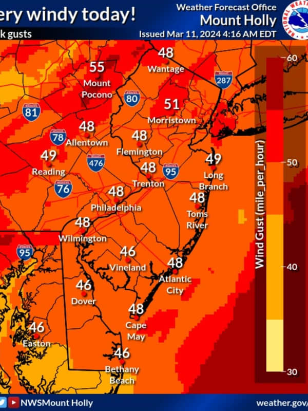
50 MPH Winds Knock Power To More Than 30K New Jersey Residents
Wind gusts nearing 50 miles per hour left thousands of New Jersey residents without power Monday, March 11.
According to the National Weather Service, winds are expected to die down in the evening with a wind advisory in effect until 11 p.m.
Skies will be mostly cloudy with a high near 50.
As of 4:15 p.m., the following areas did not have power:
JCP&L:
Hunterdon County: 4,264 without power mostly in Bethlehem, Glen Gardner, Hampton, Hampton, High Bridge, Lebanon, Readington
Middlesex County: 8,359 without power mostly in Monroe Township
Morris County: 10,049 mostly in…
Snow, Hail Could Be Part Of Damaging Mid-Week Storm Headed To NJ, PA: Forecasters
Forecasters are tracking a gusty storm bringing rain and some snow to parts of New Jersey and Pennsylvania.
Rain is expected to begin across both states Tuesday evening, Feb. 27, and continue through Wednesday morning, Feb. 28, the National Weather Service says.
☔️ Multiple rounds of rain & storms will occur across central PA through Wednesday evening, Stay Weather Aware!
1⃣: Tues... Posted by US National Weather Service State College PA on Tuesday, February 27, 2024
While temperatures on Wednesday could reach a high of 60, a steep drop is expected in the evening to around 30, …
Here's Who Got The Most Snow In North Jersey During 2nd Storm Of The Week
Four inches of snow at most was expected in the second snow storm of the week in New Jersey and Pennsylvania.
But much more fell.
In the Friday, Feb. 16 and Saturday, Feb. 17 storm, up to 13 inches of snow fell in some towns across the region, according to the National Weather Service.
Here's who got the most snow, according to the National Weather Service:
ATLANTIC, NJ: Beuna Vista, 3.3 inches; Hammonton, 2.8 inches; Somers Point, 2.2 inches
BERKS, PA: Lyons, 12 inches; Fleetwood, 9 inches; Blandon, 8.5 inches
BERGEN, NJ: Westwood 3 inches; Fair Lawn 2.5 inches; River Vale 2 …
Murphy Urges NJ Residents Work From Home, Stay Off Roads Ahead Of Winter Storm
New Jersey Gov. Phil Murphy is urging residents to stay off the roads ahead of a winter storm expected Monday, Feb. 12 into Tuesday, Feb. 13.
The National Weather Service was predicting up to 18 inches of snow in the northernmost part of the state, with between 6 inches and a foot possible across Sussex, Warren, Morris, Hunterdon, Somerset, Passaic, Bergen, and western Essex counties, where a Winter Storm Warning was issued.
Murphy said the most intense stretch of precipitation, beginning as rain and turning to snow, will happen in the middle of the night and run into mid-morning…
Foot Of Snow Could Fall In Bergen County In Major Storm, NWS Says
The National Weather Service says parts of New Jersey and Pennsylvania could see more snow than what was initially predicted due to a shift in the storm track.
In an updating briefing published Monday, Feb. 12, the NWS said 12 to 18 inches of snow could fall in parts of Sussex County, NJ and the Pocono Mountains.
ALSO SEE: North Jersey School Closed, Delayed Ahead Of Major Winter Storm
The weather map shows between 8 and 12 inches expected in parts of Bergen, Morris, Passaic, Essex, Warren, Somerset and Hunterdon counties, where winter storm warnings have been issued. Winter weather a…
Chance Of Snow For Parts Of Bergen County In Early-Week Storm: Forecasters
Temperatures are expected to surge near 60 by the end of the week, but come next, parts of New Jersey and Pennsylvania could be back in old man winter's grip, forecasters say.
According to AccuWeather, a storm on Sunday, Jan. 29 will bring rain to major cities.
For northwest New Jersey, northern Pennsylvania and parts of Central Pennsylvania, however, a mix of rain and snow — or perhaps just snow — is expected.
Thursday, Jan. 25 will be rainy and foggy with a high near 50 while Friday, Jan. 26 will be the same but slightly cooler, the NWS said. Saturday will be partly sunny with a hi…
Sleet, Freezing Rain, Snow To Blast Parts Of North Jersey Before Warmup: Forecasters
Warmer days are coming, but not before another bout of wintry weather, forecasters say.
Sunday night, Jan. 21 will be frigid with temps in the mid-teens while Monday, Jan. 22 will be sunny with increasing clouds and a high in the mid-30s, the according to the National Weather Service.
Monday night will be dry with a low around 27, however, a wintry mix is expected to arrive Tuesday, Jan. 23, with sleet possible in the morning in Sussex, Warren, Bergen, and Passaic counties — primarily north of Route 78, the NWS said. Temps will be in the mid-30s.
There's a chance of rain fo…
New Forecast: Increased Snowfall Totals Expected, Arctic Temps To Follow Northeast Storm
Newly-released forecast maps show parts of the region could see up to six inches of snow in the end-of-week storm.
Intermittent snow is expected to begin between 4 and 7 a.m. Friday, Jan. 19, with the heaviest amounts falling in the afternoon, the National Weather Service said.
Snow will fall at about 0.5 inches per hour and will taper by the evening, with temps in the upper 20s and low 30s, the NWS said.
SNOWFALL PREDICTIONS
The areas expected to get 4 to 6 inches are Trenton, Long Branch, Allentown, and Philadelphia. Reading, Vineland, Parsippany and Toms River are expected to get 3 to …
Six Inches Of Snow Could Slam Parts Of NJ, PA: Latest Forecast, Timing Updates
Newly-released forecast maps from the National Weather Service show up to six inches of snow could fall across eastern Pennsylvania and much of New Jersey.
Accumulating snowfall will begin Monday, night Jan. 15, mainly after 7 p.m., and carry into Tuesday morning, Jan. 16, impacting the morning commute as it changes over to a wintry mix, the NWS said in its latest briefing.
ALSO SEE: North Jersey School Delays For Tuesday, Jan. 16
Between 4 and 6 inches of snow was being forecast for most of North Jersey (including Morris, Sussex, pars of Bergen/Essex/Hudson, Warren, and Hunterdon Counties…
Possibility Of Snow, Ice Storm For Northeast Next Week Hinges On One Factor: AccuWeather
A winter storm could hit the Northeast next week, but it depends on one factor, forecasters say.
A dip in the jet stream.
“Should a large dip develop in the jet stream, then a major winter storm will climb the Atlantic coast from Monday night to Tuesday night,” AccuWeather Senior Meteorologist Bob Smerbeck explained.
“However, should only a shallow dip in the jet stream develop, the storm would be more likely to escape out to sea, off the southern Atlantic coast by midweek.”
Weather maps show a dusting of between one and three inches, should the snow make its way up to New Jersey, eastern…